“Super Load” Round 2 Begins March 14th
Article Presented By Classic Brands…
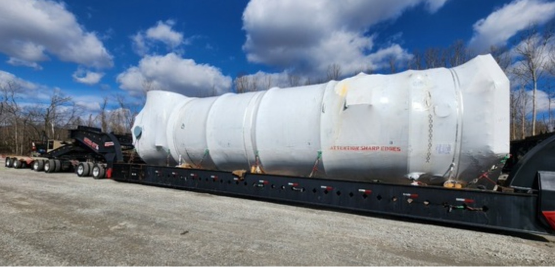
(Columbus) – One week after the first “super load” headed out from Adams County, an identical second is due to follow the same route next week.
The Ohio Department of Transportation and Ohio State Highway Patrol will escort the second large load beginning Thursday, March 14th. It is scheduled to depart the same dock east of Manchester around 8am.
Like the first load, this one weighs 390,000 pounds, is 18’3″ tall, 18’6″ wide, and 200′ long and will be delivered to Hebron. It is not related to the Intel plant being built in Licking County.
Due to St. Patrick’s Day, the city of Columbus will not allow the load to move through the city on Sunday, March 17th, so it will remain at Rickenbacker Airport until Saturday, March 23rd. It is scheduled to reach Hebron on Monday, March 25.
This is the second of nearly two dozen scheduled to move over the next several months. The largest loads will tip the scales at 900,000 pounds, 19 feet wide, 24 feet high, and 270 feet long. Each oversized and overweight load will take approximately 8-15 days to reach its destination. While no official closures or detours are planned, slow-rolling roadblocks will be necessary during transit, and drivers should plan ahead for long delays along the route.
The Ohio Department of Transportation has carefully analyzed and planned the route to make sure these super loads can be accommodated. Since each load will be escorted by several Ohio State Highway Patrol troopers, emergency traffic will get around the rolling roadblock with minimal delay. Working with partners like local governments and utility companies, obstructions along the route such as large overhead signs, traffic signals, and utility lines have been adjusted and moved.
The schedule of each of these loads will be checked against local events, like festivals and fairs, to further minimize impacts.
Notifications will be made in advance of each load leaving the dock on the Ohio River near the village of Manchester in Adams County. Updates will be provided as each load moves north toward central Ohio.
 |
The route the loads will follow includes:
- From the dock site east of Manchester, it will travel east on U.S. 52 to West Portsmouth.
- At west Portsmouth, cross over into the U.S. 52 westbound lanes just before the junction of the SR 239 on ramp to U.S. 52 Westbound.
- Travel north on the SR 239 Southbound ramp to SR 73/SR 104
- Travel south in the Northbound lanes of State Route 73/SR 104 to US 52
- Travel east on U.S. 52 in the Westbound lanes to U.S. 23 in Portsmouth
- Travel north on U.S. 23 southbound ramp to U.S. 52 westbound
- Travel north on U.S. 23 in the northbound lanes to the intersection with Kinneys Lane and Argonne Road
- Cross over into the northbound lanes and travel north on U.S. 23 to the Village of Piketon
- In the Village of Piketon cross over into the Southbound lanes of U.S. 23 at Market Street to maneuver around the traffic signals then cross back over into the northbound lanes of U.S. 23
- Travel north on U.S. 23 to Chillicothe
- Take U.S. 35 West to SR 104 north
- Take SR 104 North to SR 762 near Commercial Point
- Travel east on SR 762 to Rickenbacker Parkway
- Travel north on Rickenbacker Parkway north to Alum Creek Drive
- Travel north on Alum Creek Drive to Rohr Road
- Travel east on Rohr Road to Commerce Center Drive
- Travel north on Commerce Center Drive to Green Pointe Drive south
- Travel east on Green Point Drive south to Saltzgaber Road
- Travel south on Saltzgaber Road to SR 317
- Travel north in the southbound lanes on SR 317 past Groveport to Bixby Road east
- Travel east on Bixby Road to U.S. 33
- Travel east in the Westbound lanes of U.S. 33 to the Gender Road southbound to U.S.33 westbound ramp in Canal Winchester
- Travel the wrong way on the Gender Road southbound to U.S. 33 Westbound ramp
- Take SR 674/Gender Road north to Brice Road
- Take Brice Road north to the intersection with Tussing Road/SR 204 in Columbus
- Travel east on Tussing Road/SR 204 East to SR 310
- Travel north on SR 310 to U.S. 40 in Etna
- Travel east on U.S. 40 to SR 79 in Hebron
- Travel the wrong way on the SR 79 southbound off ramp to U.S. 40
- Travel north in the southbound lanes on SR 79 to local roads


